





信州防災アプリ
長野県
Description of 信州防災アプリ
দুর্যোগের প্রস্তুতিতে দুর্যোগ প্রতিরোধ শিখুন। এটি অফিসিয়াল নাগানো প্রিফেকচার অ্যাপ যা সাধারণত জরুরী অবস্থার ক্ষেত্রে উপকারী।
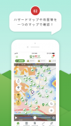
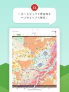
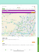
স্থানান্তরের সিদ্ধান্ত নেওয়ার জন্য প্রয়োজনীয় তথ্যের পুশ বিজ্ঞপ্তি দ্বারা আমরা আপনাকে অবহিত করব, যেমন আপনার বর্তমান অবস্থান, নির্বাচিত স্থানান্তর তথ্য এবং নির্বাসন আশ্রয়কেন্দ্রের খোলার / বন্ধের অবস্থা। উপরন্তু, উপরের পৃষ্ঠা থেকে, খোলা উচ্ছেদ কেন্দ্রের অবস্থান এবং বিপদ ম্যাপ ছাড়াও, বর্তমান বৃষ্টির মেঘের তথ্যও একটি মানচিত্রে প্রদর্শিত হয়।
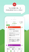
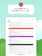
তদুপরি, যদি আপনি আগে থেকে "আমার নির্বাসন পরিকল্পনা" তৈরি করেন, তাহলে আপনি এটি আপনার পরিবার এবং পরিচিতদের সাথে ভাগ করে নিতে পারেন, যা জরুরী পরিস্থিতিতে আপনাকে সরিয়ে নিতে সাহায্য করবে।
এছাড়াও, প্রচুর পরিমাণে বিষয়বস্তু রয়েছে যেমন শিনশু দুর্যোগ প্রতিরোধ নোটবুক, দুর্যোগ প্রতিরোধ শেখার কুইজ এবং কলাম যেখানে আপনি সহজেই দুর্যোগ প্রতিরোধ জ্ঞান শিখতে পারেন।
"প্রধান কার্যাবলী"
・ আমার উচ্ছেদ পরিকল্পনা
・ সরিয়ে নেওয়ার তথ্য
· দুর্যোগ তথ্য
Current আপনার বর্তমান অবস্থানের আশেপাশে নির্ধারিত জরুরী নির্বাসন সাইট অনুসন্ধান করুন
Shel খোলা আশ্রয়গুলির জন্য অনুসন্ধান করুন
・ বিপত্তি মানচিত্র পলি-সম্পর্কিত দুর্যোগ সতর্কতা এলাকা, প্লাবিত এলাকা ইত্যাদি প্রদর্শন করে।
Rain বৃষ্টির মেঘের চলাচল
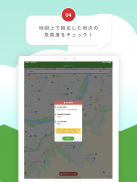
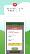
Current আপনার বর্তমান অবস্থান এবং নির্ধারিত পয়েন্টগুলির ঝুঁকির মাত্রা পরীক্ষা করুন
In শিনশু দুর্যোগ প্রতিরোধ নোটবুক
・ দুর্যোগ প্রতিরোধ কলাম
・ দুর্যোগ প্রতিরোধ কুইজ
・ দুর্যোগ প্রতিরোধ লিঙ্ক


